Quick answer
Cool 15–25°C climate; driest Nov–Mar, heaviest rain May–Oct afternoons. Arrive via DLI (30 km) or buses: HCMC 6–8h, Nha Trang 3–4h. See Pongour, Elephant, Datanla; Xuan Huong and Tuyen Lam lakes. Canyoning at Datanla, hike Langbiang, visit Cau Dat coffee farms.
Why this guide
About this guide
Da Lat sits at roughly 1,500 metres above sea level on the Lang Bian Plateau in Lâm Đồng Province, where the Langbiang mountain range frames a landscape of pine-forested hills, lakes, and valleys. Temperatures hold between 18 and 23°C year-round — a sharp contrast to the lowland heat — which is why French colonists developed the town from the early 1900s as a highland retreat. That colonial period left a durable architectural imprint: the 1932-built railway station, art-deco hotels, and Bao Dai's Summer Palace remain in use or open to visitors today. The dry season, December through March, with temperatures averaging 14–23°C, is the most practical window for trekking and waterfall visits.
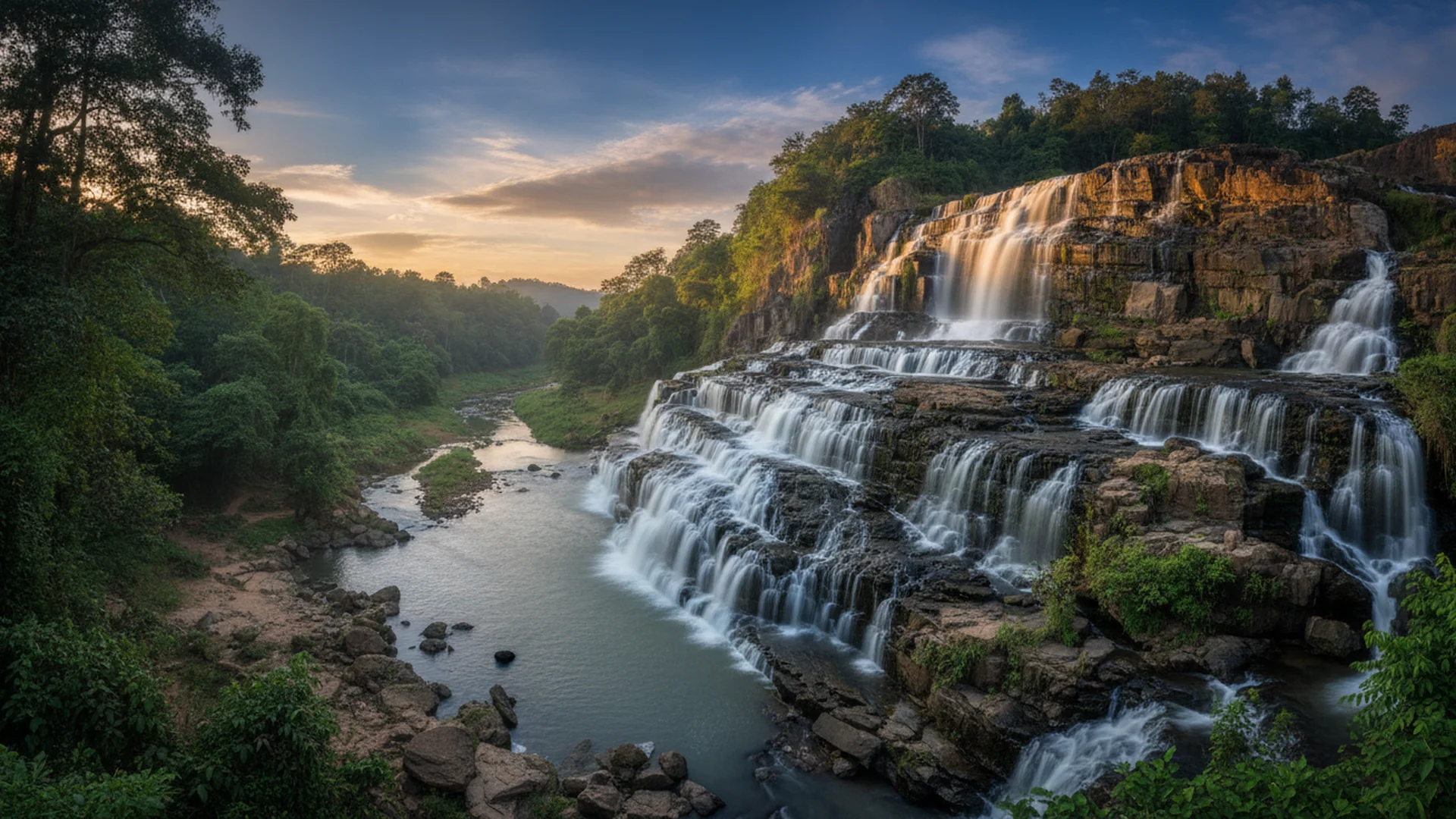
The terrain around Da Lat supports a network of waterfalls fed by highland streams. Datanla Falls, 5–8 km from the city centre along Highway 20, is the easiest to reach, dropping about 20 metres across seven tiers; the site also runs a 1,000-metre zipline and an alpine roller coaster. Pongour, roughly 50 km out, falls 40 metres over seven wide rock tiers and is accessible on foot during the dry season. Dambri, the tallest waterfall in Lâm Đồng Province at 57 metres high and 30 metres wide, sits further afield but draws visitors for its size and the tropical forest surrounding it. For those after more physical engagement, canyoning at Datanla — combining abseiling, swimming, and climbing — is the area's most established adventure activity, with water volume highest in the rainy season from May to October.
Coffee has been part of Da Lat's agricultural identity since 1898, when French colonists planted Arabica seeds brought from Africa and worked with the K'Ho minority as the region's first coffee farmers. The altitude, temperate climate, and red basaltic soil favour Arabica varieties, including the locally prized Moka and the labour-intensive Weasel Coffee, producing a cup noted for mild acidity and floral, fruity character rather than the bold profile of Robusta common elsewhere in Vietnam. The K'Ho Coffee cooperative, founded in 2012 by fourth-generation farmer Rolan Co Lieng on Langbiang Mountain's slopes, processes beans using washed, natural, and honey methods. La Viet Coffee, operating from 200 Nguyen Cong Tru since 2013, runs free tours of its roasting and processing facility and sources directly from highland farms, representing the newer wave of specialty operations Vietnam Tourism has described as central to a broader shift in how Vietnamese coffee is produced and consumed.
Key facts & good to know
What defines the geography of Da Lat and what activities does the altitude support?
Da Lat sits at roughly 1,500 metres on the Lang Bian Plateau in Lâm Đồng Province. The elevation drives year-round temperatures of 18–23°C, supporting Arabica coffee cultivation, pine-forest hiking, waterfall visits, and colonial-era sightseeing across the city's French-built core.
The city occupies a rolling highland basin ringed by the Langbiang mountain range, where pine-forested slopes drop into narrow valleys and lake-filled hollows. Lang Biang Mountain reaches 2,167 metres and anchors Bidoup Nui Ba National Park, a 70,000-hectare reserve on the city's doorstep that draws multi-day trekkers and birdwatchers. The K'Ho people have farmed these slopes for centuries, establishing the agricultural patterns that French colonists later formalised into coffee and vegetable production.
French planners developed Da Lat from the early 1900s as a highland retreat, leaving behind colonial villas, an art-deco railway station dating to 1932, and Bao Dai's Summer Palace. That built heritage now attracts domestic tourists escaping coastal heat, while the fertile red basaltic soil draws agricultural tourism visitors to coffee cooperatives, strawberry farms, and flower nurseries. The combination of altitude, architecture, and active outdoor options — canyoning, summit hikes, waterfall circuits — makes the city a functional base for several distinct visitor demographics.
Plan a Da Lat trip
Where to stay, when to go, and how to combine the highlights of Da Lat into a paced stopover.
Which months offer the driest weather for trekking and agriculture tours?
November through April is Da Lat's dry season, with temperatures averaging 14–23°C. Wild sunflowers peak in November, cherry blossoms appear in January, and coffee harvesting runs through the dry months. Waterfall volume drops, improving trail access to Pongour and Datanla on foot.
The dry season (November–April) keeps trail surfaces firm and river crossings manageable, which matters most for the Pongour Waterfall approach — the 50 km drive south ends in a short hike that becomes slippery in wet conditions. December through March sees the lowest recorded temperatures (around 14°C at night) and the clearest skies, making these months the practical peak for both trekking and photography. Agricultural cycles align with this window: coffee cherries are harvested from roughly November onward, wild sunflowers along the roadsides peak in November, and ornamental cherry blossoms flower through January.
The rainy season (May–October), with the heaviest rainfall in August and September, significantly raises water volume at all falls. Datanla's seven cascades and Dambri's 57-metre drop are more dramatic visually during this period, but canyoning operators adjust programming around water levels and occasionally suspend trips. Hiking trails into Bidoup Nui Ba become muddier and some secondary paths close. Visitors focused on waterfall scenery rather than trekking access may still find May–October workable, particularly in the earlier weeks of the wet season before August peaks.
Da Lat seasonal conditions by activity type
| Season | Months | Avg Temp Range | Waterfall Access | Trekking Trails | Agricultural Highlight |
|---|---|---|---|---|---|
| Dry (peak) | Dec–Mar | 14–23°C | Low volume, easy trail access | Firm, accessible | Coffee harvest; cherry blossoms (Jan) |
| Dry (shoulder) | Nov, Apr | 16–23°C | Moderate volume | Generally good | Wild sunflowers (Nov); coffee harvest begins |
| Rainy (early) | May–Jul | 17–22°C | High volume, dramatic flow | Muddy, caution advised | Vegetable and flower growing season |
| Rainy (peak) | Aug–Sep | 17–21°C | Very high volume; some trails closed | Some closures | Limited agricultural tours |
| Rainy (late) | Oct | 17–22°C | Easing, still elevated | Improving | Pre-harvest preparation |
Temperature range sourced from Da Lat city-level data for the Lang Bian Plateau at ~1,500 m elevation. Agricultural peaks are approximate and vary by farm elevation and variety.
How long does transit take from Ho Chi Minh City or Nha Trang to Da Lat?
Sleeper buses from Ho Chi Minh City cover 300 km in 6–8 hours. From Nha Trang, the 140 km route over the Khanh Le Pass takes 3–4 hours by road. Lien Khuong Airport (DLI) sits 30 km south of the city center.
Lien Khuong Airport (IATA: DLI) handles domestic connections from Hanoi, Ho Chi Minh City, and a small number of other Vietnamese cities. The airport is located 30 km south of central Da Lat; taxi transfers to Ward 1 typically take 35–45 minutes depending on traffic and the mountain road gradient. Grab operates in Da Lat and provides a metered alternative to negotiated taxi fares for both airport transfers and intra-city trips.
Overland travel is straightforward from two main origin points. Sleeper buses departing from Ho Chi Minh City's An Suong or Mien Dong stations cover approximately 300 km and arrive in 6–8 hours depending on operator and stops; several companies run overnight departures. The Nha Trang route crosses the Khanh Le Pass — a mountain road with steep gradients and hairpin bends over 140 km — in roughly 3–4 hours by shared minibus or private vehicle. Within Da Lat, metered taxis, Grab cars, and Grab bikes handle most point-to-point trips. Scooter rentals are available through guesthouses and specialist shops for visitors comfortable with highland mountain roads.
Transit options to Da Lat by origin and mode
| Origin | Mode | Distance | Journey Time | Notes |
|---|---|---|---|---|
| Ho Chi Minh City | Sleeper bus | ~300 km | 6–8 hours | Multiple overnight departures; An Suong or Mien Dong stations |
| Ho Chi Minh City | Flight + transfer | ~300 km (air) | 1 hr flight + 35–45 min transfer | DLI airport 30 km south of city center |
| Nha Trang | Minibus / private car | ~140 km | 3–4 hours | Khanh Le Pass: steep gradients, hairpin bends |
| Da Lat city center | Grab / metered taxi | Varies | 5–30 min | Grab operational in Da Lat; confirm driver accepts before boarding |
| Da Lat city center | Scooter rental | Varies | Self-determined | Available via guesthouses; highland roads require experience |
Journey times are estimates and subject to road conditions, mountain weather, and operator schedules. Always confirm current bus timetables with the operator directly.
The 140 km Nha Trang–Da Lat road crosses the Khanh Le Pass, which includes steep gradients and sharp bends prone to fog and reduced visibility, particularly in the rainy season (May–October) and early mornings year-round. Self-driving scooters on this route carries elevated risk. If renting a scooter within Da Lat, confirm that your travel insurance policy covers motorcycle use in Vietnam before departing.
Which waterfalls, lakes, and coffee plantations fit into a 3-day itinerary?
Group sites by geographic zone: Day 1 covers the city center, Day 2 follows a southern loop to Datanla and Tuyen Lam Lake, and Day 3 reaches outer districts for tea hills, K'Ho coffee farms, or the Lang Biang summit hike at 2,167 metres.
Day 1 stays within the walkable city core. Xuan Huong Lake at the center requires no entry fee and anchors a flat circuit past the 1932 railway station and French-era market. Bao Dai's Summer Palace (Palace 1) charges a modest entry fee and sits within a few kilometers of the lake. Crazy House (Hang Nga Guesthouse) is a short taxi or Grab ride away and operates as both a working guesthouse and ticketed attraction. La Viet Coffee at 200 Nguyen Cong Tru offers free roastery and processing lab tours and serves as a practical introduction to Da Lat's Arabica production before heading into the farms.
Day 2 runs a southern loop starting 5–8 km from the center at Datanla Waterfall, where the alpine roller coaster descends alongside the 20-metre cascade and a 1,000-metre zipline operates through the pine forest. Continuing south, Tuyen Lam Lake (approximately 7 km from center) allows kayaking and connects by cable car to Truc Lam Monastery on the hill above. Day 3 extends further out: Cau Dat tea plantation sits in the highlands, the K'Ho Coffee cooperative operates on the slopes of Langbiang Mountain and offers direct-farm visits, and Lang Biang Mountain's 2,167-metre summit is reachable by jeep to the trailhead followed by a hike. Pongour Waterfall, at 50 km from the city with its 40-metre, seven-tiered drop, requires a half-day dedicated trip and fits best as an add-on day or substitution within Day 3.
Da Lat 3-day site clusters: distances and key details
| Day | Site | Distance from Center | Key Feature | Entry / Activity Note |
|---|---|---|---|---|
| Day 1 | Xuan Huong Lake | <1 km | Central lakefront circuit | No entry fee |
| Day 1 | Bao Dai Summer Palace (Palace 1) | 2–3 km | Colonial-era summer residence | Ticketed entry |
| Day 1 | La Viet Coffee roastery | ~2 km | Free processing and roasting lab tour | Free tour; single-origin sourcing |
| Day 2 | Datanla Waterfall | 5–8 km | 20 m cascade; alpine coaster; 1,000 m zipline | Ticketed; activity fees separate |
| Day 2 | Tuyen Lam Lake | ~7 km | Kayaking; cable car to Truc Lam Monastery | Cable car ticketed; kayak hire on-site |
| Day 3 | Cau Dat tea hills | ~25 km | Working highland tea plantation | Varies by operator |
| Day 3 | K'Ho Coffee cooperative | Langbiang slopes | Fourth-generation Arabica farm; washed/natural/honey processing | Direct farm visit; confirm booking |
| Day 3 | Lang Biang Mountain summit | ~12 km to trailhead | 2,167 m; jeep to base, hike to top | Jeep fee + park entry |
| Add-on | Pongour Waterfall | ~50 km | 40 m drop; seven rock tiers | Half-day trip; dry season access recommended |
Distances are approximate road distances from Da Lat city center (Ward 1). Entry fees change periodically; confirm current rates on arrival or with your accommodation.
Canyoning at Datanla Falls involves abseiling, swimming, and sliding in active waterways. During the rainy season (May–October), water volume increases significantly and operators may suspend or modify routes without advance notice. Use only operators that provide certified guides and inspect equipment before each descent. Confirm that your travel insurance covers adventure activities before booking.
Which neighborhoods provide the most efficient access to central Da Lat versus nature reserves?
Ward 1 around Hoa Binh gives walkable access to the Night Market and cafes. Wards 3 and 4 offer mid-range properties 2–3 km out. Tuyen Lam Lake resorts sit 7 km south. Farmstays in Xuan Tho or Ta Nung suit agricultural immersion.
Ward 1, centered on the Hoa Binh area, places visitors within walking distance of the Night Market, the central market hall, Xuan Huong Lake, and the cluster of specialty cafes along Nguyen Chi Thanh and surrounding streets. Accommodation here ranges from budget guesthouses to mid-range boutique hotels, with nightly rates that reflect the central location. This zone suits visitors prioritising ease of movement on foot and proximity to Da Lat's street food and cafe culture without relying on taxis for every meal.
Wards 3 and 4 sit on the pine-forested hills 2–3 km from the Ward 1 core, where guesthouses and small hotels occupy quieter slopes at slightly lower average rates than the center. Tuyen Lam Lake, 7 km south of the city, hosts resort properties with lakefront or hillside settings; the trade-off is taxi or Grab dependence for every city-center trip, though the lake itself provides kayaking and the cable car to Truc Lam Monastery on-site. Farmstays in the Xuan Tho and Ta Nung valleys — both within the outer agricultural districts — offer direct immersion in working flower, vegetable, or coffee farms and suit multi-night stays focused on agricultural tourism rather than urban sightseeing.
Da Lat accommodation zones: logistics and approximate nightly rates
| Zone | Distance from Center | Access Mode | Avg Nightly Rate (USD) | Best For |
|---|---|---|---|---|
| Ward 1 (Hoa Binh area) | <1 km | Walking | $20–$60 | Night Market, cafes, daily sightseeing on foot |
| Wards 3 & 4 (pine hills) | 2–3 km | Grab / taxi / scooter | $15–$45 | Quieter stays; mid-range properties; short ride to center |
| Tuyen Lam Lake | ~7 km south | Taxi / Grab | $60–$150+ | Resort stays; kayaking; cable car to Truc Lam Monastery |
| Xuan Tho / Ta Nung farmstays | 10–15 km | Scooter / private transfer | $25–$70 | Agricultural immersion; coffee and flower farm access |
Nightly rate ranges are approximate and reflect mid-range options at time of research. Rates rise significantly during Vietnamese public holidays and the December–January peak. Confirm current pricing directly with properties.
Da Lat attractions & tickets
Pre-purchased entrance tickets, private transfers and certified guides — no queues, no logistics hassle.
Building a da-lat itinerary for your clients?
Send us your dates and pace — we return a realistic, booked-and-paced plan with net rates, not a generic template.
Want this tailored to your dates?
We run these routes ourselves. Send your dates, group size and pace and our Hanoi team will build a custom version — with real prices, not estimates.
Frequently asked questions
People also ask
Verified sources
- ATL DMC booking log · 12,000+ trips since 2011
- Vietnam Tourism – Things to Do in Da Lat · https://vietnam.travel/things-to-do/8-things-to-do-in-dalat
- Vietnam Tourism – Da Lat Destination Page · https://vietnam.travel/places-to-go/central-vietnam/dalat
- Vietnam Tourism – Coffee Tour in Da Lat · https://vietnam.travel/things-to-do/da-lat-tour-coffee-lovers
- Vietnam Tourism – Cool Cafes: La Viet & The Married Beans · https://vietnam.travel/things-to-do/cool-cafes-vietnam
- Rough Guides – Da Lat and Around · https://www.roughguides.com/vietnam/the-central-highlands/da-lat-and-around/
- Wikivoyage – Da Lat · https://en.wikivoyage.org/wiki/Da_Lat
- Vietnam Tourism Information – Da Lat Waterfalls · https://www.vietnamtourism.org.vn/travel-guide/destination-in-vietnam/da-lat-and-majestic-waterfalls.html
Turn this guide into a trip
The products we actually run for this route — book direct, no OTA markup.
Plan your custom trip with Phuong Le
Phuong Le
“Tell us your dates and pace — we'll turn this guide into a realistic, booked-and-paced trip for you, not a generic template.”
Plan my trip with our team →About the authors
Phuong Le · primary author
Specialty: Hanoi · Halong Bay · Vietnam itineraries.
Cross-category lattice
Plan your trip
Practical
Related travel guides
1× per month · pillar guides + new itineraries
Get our newest pillar guides + quarterly itinerary updates delivered. No spam, no promotions, just travel-guide content. Unsubscribe anytime.