Quick answer
Spend 3–5 days (350–550 km). Route: Ha Giang–Yen Minh–Dong Van–Ma Pi Leng–Meo Vac–Du Gia; add Bao Lac for +1 day. Ride 80–150 km/day. Border permit ~200k–250k VND in Ha Giang City. Valid license + IDP advised. Rent 150k–300k VND/day; easy rider 700k–1.2m. Drier months Mar–May, Sep–Nov.
Why this guide
About this guide
The Ha Giang Loop is a roughly 350 km circular motorbike route through Ha Giang Province in northern Vietnam, starting and ending in Ha Giang City. Traveling clockwise along National Highway QL4C, riders pass through Quan Ba, Yen Minh, Dong Van, Meo Vac, and Du Gia before returning to the city. Most travelers complete the circuit in 3–4 days, though extending to 5–7 days allows side trips to Cao Bang, Ban Gioc Waterfall, Hoang Su Phi, or the terraced fields around Bac Ha.
The route passes through the Dong Van Karst Plateau UNESCO Global Geopark, a 2,356 km² protected area spanning four districts at an average elevation of 1,400–1,600 m above sea level, where 60–80% of the surface is limestone. Recognized on 3 October 2010 as Vietnam's first UNESCO Global Geopark and only the second in Southeast Asia at the time, the plateau holds geological formations spanning more than 550 million years, with fossils including trilobites, brachiopods, ancient fish, and conodonts. Tu San Canyon, carved by the emerald-green Nho Que River, reaches depths of 700–800 m, placing it among the deepest canyons in Southeast Asia. Seventeen ethnic minority groups, led by the Hmong at over 60% of the local population, inhabit the geopark, some communities having lived in the region for 500–800 years.
Foreign travelers entering the northern border districts of Quan Ba, Yen Minh, Dong Van, and Meo Vac are legally required to carry a Border Area Permit, enforcement of which has been active since June 2026. The permit costs approximately 200,000–250,000 VND (around USD $10) per person, remains valid for up to 30 days from the issue date, and can be obtained at the Ha Giang Immigration Office at 415a Tran Phu Street, open daily from 8 am to 8 pm with a midday break, or through a local accommodation provider or tour operator. Riders must also carry a valid home-country motorcycle licence and a 1968 Vienna Convention International Driving Permit; operating a bike without one risks fines of 2–8 million VND, possible vehicle impoundment, and voided travel insurance. Travelers without a motorcycle licence can join a guided Easy Rider tour, where a licensed local driver operates the bike, or book a private jeep tour.
Key facts & good to know
How do you travel from Hanoi to Ha Giang City?
Ha Giang City sits roughly 310–320 km north of Hanoi — about 6–7 hours by road. Buses depart Hanoi twice daily for approximately 420,000 VND. VIP cabin buses and private car transfers are also available at higher cost.
The standard option is a sleeper or semi-sleeper bus departing from My Dinh Bus Station or pick-up points in the Old Quarter. Buses run twice daily and the fare sits around 420,000 VND (~USD $17) per seat. Journey time is typically 6–7 hours depending on road conditions, with overnight departures arriving in Ha Giang City by early morning — convenient if you want to collect your permit and rent a bike the same day.
VIP cabin buses offer fold-flat pods and are a step up in comfort, though they cost roughly double the standard fare and do not always depart from the same terminals. Private car transfers give you flexibility on departure time and door-to-door convenience but are the most expensive option. If you plan to rent a motorbike in Ha Giang rather than ride one from Hanoi, any of the three methods works; if you intend to ride your own bike north, factor in an additional full day of riding on National Highway QL2.
Hanoi to Ha Giang City: Transport Options Compared
| Method | Distance | Duration | Approx. Cost (VND) | Departure Point | Notes |
|---|---|---|---|---|---|
| Standard sleeper bus | 310–320 km | 6–7 hrs | ~420,000 | My Dinh Bus Station / Old Quarter pick-up | Twice-daily departures; reclining seats |
| VIP cabin bus | 310–320 km | 6–7 hrs | ~800,000–1,000,000 | My Dinh Bus Station / Old Quarter pick-up | Fold-flat pods; limited schedules |
| Private car transfer | 310–320 km | 6–7 hrs | ~2,500,000–4,000,000 | Flexible — hotel pick-up | Door-to-door; negotiate in advance |
| Self-ride motorbike | 310–320 km | 8–10 hrs | Fuel + tolls ~200,000–300,000 | Hanoi city | Requires valid licence and IDP; adds a full day |
Costs are approximate estimates. VIP cabin and private car prices vary by operator and season. Confirm current bus schedules on arrival at My Dinh or via your accommodation.
Plan a Vietnam trip
Where to go, when to travel, and how a local ground operator builds a paced Vietnam itinerary.
Which route itinerary should you choose — 3, 4, or 5 days?
The loop covers roughly 350 km total. Three days is feasible but demanding. Four days suits most riders. Five or more days allows side trips and a more comfortable daily riding pace of 80–100 km.
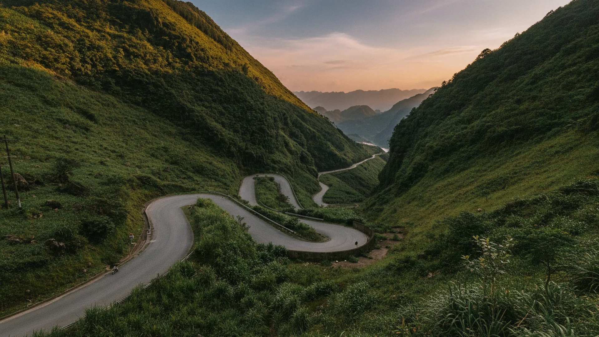
The clockwise direction — Ha Giang → Quan Ba → Yen Minh → Dong Van → Meo Vac → Du Gia → Ha Giang — is the most commonly ridden sequence and is recommended for first-time riders. It places the steepest climb (Heaven's Gate Pass at Quan Ba) early on day one when riders are fresh, and saves the dramatic Ma Pi Leng Pass (~20 km, ~1,500 m elevation) for day two or three when you are more comfortable with mountain roads. Counterclockwise reverses this logic: you hit Ma Pi Leng first, which some experienced riders prefer for the light direction, but the final day's descent into Ha Giang via Quan Ba is harder to judge for newcomers.
The core loop is approximately 350 km. A 3-day itinerary compresses segments significantly — expect 110–130 km per riding day with limited stops. A 4-day plan allows roughly 80–100 km per day, which is more manageable given road conditions, checkpoints, and permit inspections. Extending to 5 days gives room to add the Lung Cu Flag Tower (Vietnam's northernmost point, a 24 km return detour from Dong Van), the Du Gia riverside area, or a full morning at the H'mong King's Palace without feeling rushed. Side trips to Cao Bang, Ban Gioc Waterfall, or the terraced fields around Bac Ha add two or more additional days beyond the core loop.
Ha Giang Loop Itinerary Options: Daily Segments (Clockwise)
| Day | Segment | Distance | Est. Riding Time | Key Stops |
|---|---|---|---|---|
| Day 1 | Ha Giang → Yen Minh (via Quan Ba) | ~100 km | 3.5–4 hrs | Heaven's Gate Pass (Quan Ba), Twin Mountains |
| Day 2 | Yen Minh → Dong Van | ~60 km | 2–2.5 hrs | H'mong King's Palace, Dong Van Old Quarter |
| Day 2 optional detour | Dong Van → Lung Cu Flag Tower return | ~24 km return | ~1 hr return | Lung Cu Flag Tower (Vietnam's northernmost point) |
| Day 3 | Dong Van → Meo Vac | ~25 km | 1–1.5 hrs | Ma Pi Leng Pass (~20 km, ~1,500 m elevation), Tu San Canyon viewpoint |
| Day 3/4 | Meo Vac → Du Gia | ~110 km | 4–5 hrs | Nho Que River, Du Gia village |
| Final day | Du Gia → Ha Giang City | ~50 km | 1.5–2 hrs | Return to city; bike drop-off |
Distances are approximate. Riding times assume stops at checkpoints, photo points, and fuel stations. The Meo Vac–Du Gia stretch includes unpaved sections and should not be ridden after dark.
What licences, permits, and insurance do you legally need for the Ha Giang Loop?
You need a valid home-country motorcycle licence plus a 1968 Vienna Convention IDP with a motorcycle endorsement. You also need a Border Area Permit, costing 200,000–250,000 VND, to enter the four northern districts.
Vietnam recognises only the 1968 Vienna Convention International Driving Permit (IDP). If your home country issued a 1949 Geneva Convention IDP instead, it is not valid in Vietnam — police can impound the motorbike and issue fines ranging from 2 to 8 million VND. Critically, riding without a valid IDP also voids most travel insurance policies, meaning any medical costs from an accident fall entirely on you. Before booking your trip, confirm with your national motoring authority which convention your country's IDP follows, and verify with your travel insurer that motorbike riding is covered.
The Border Area Permit ('Giấy phép vào khu vực biên giới') is a separate legal requirement for the four restricted northern districts: Quan Ba, Yen Minh, Dong Van, and Meo Vac. It costs approximately 200,000–250,000 VND (~USD $10) per person and is valid for up to 30 days. You can obtain it at the Ha Giang Immigration Office at 415a Tran Phu Street, open daily 8am–8pm with a lunch break, or through your accommodation provider or tour operator. Enforcement has been active. Carry both your IDP and your permit at all times; checkpoints on QL4C will ask for both.
Only the 1968 Vienna Convention IDP is legally recognised in Vietnam. A 1949 Geneva Convention IDP is invalid. Riding on an invalid or absent IDP risks fines of 2–8 million VND and bike impoundment — and will void your travel insurance in the event of an accident, leaving you liable for all medical costs. Confirm your IDP type with your national motoring authority before departure.
What road conditions and safety protocols should you expect on the loop?
Roads include narrow mountain sections with sheer cliff drops, blind corners, no guardrails, and surfaces ranging from smooth asphalt to gravel. The three most common factors in fatal incidents are riding at night, riding under alcohol, and overbraking on descents.
The route follows National Highway QL4C through the Dong Van Karst Plateau at average elevations of 1,400–1,600 m. Road width is often one lane in practice, shared with oncoming trucks, agricultural vehicles, and livestock. Sections near Yen Minh and the Meo Vac–Du Gia stretch carry the highest rockslide risk during the rainy season (May–October). The Ma Pi Leng Pass is approximately 20 km long and reaches around 1,500 m elevation with tight switchbacks and exposed drop-offs on the valley side. Some sections have no guardrails. Road surfaces change without warning from sealed asphalt to loose gravel, particularly after rainfall. Keep speeds below 50 km/h on mountain roads and sound your horn before every blind corner to alert oncoming vehicles.
Ha Giang Provincial Hospital is the main medical facility in the region but has limited surgical and intensive-care capacity compared to Hanoi hospitals. For serious injuries, evacuation to Hanoi is typically required, which adds several hours to treatment time. For this reason, travel insurance with medical evacuation coverage is essential. Riders with little or no prior motorbike experience should seriously consider the Easy Rider option: a licensed local driver operates the bike while you ride pillion. This is a legally compliant alternative that removes both the licence requirement and the self-riding risk. Private jeep tours are a further alternative covering the same scenic route without a motorbike. Core safety rules: never ride after dark, no alcohol before or during riding, never overtake on a curve, and use engine braking on long descents rather than relying solely on the front brake.
Which motorbike should you rent and what will the loop cost in total?
Semi-automatic bikes such as the Honda Blade 110cc handle most of the route. The Honda XR150 manual is better for unpaved sections. Avoid fully automatic scooters on this route due to brake overheating risk on extended steep descents.
Most rental shops in Ha Giang City stock semi-automatic bikes (Honda Blade or similar 110cc models) and manual trail bikes (Honda XR150 or equivalent). The 110cc semi-automatic is adequate for the sealed sections of QL4C and costs less per day. The XR150 or equivalent 150cc manual handles the gravel and unpaved sections on the Meo Vac–Du Gia stretch with greater control and has more reliable engine braking on sustained downhills. Whichever bike you choose, inspect brake condition, tyre tread, and chain tension before paying. Ask for a spare inner tube, basic toolkit, and the shop's emergency contact number.
Beyond the rental fee, daily running costs include fuel (the loop's ~350 km total at typical consumption means roughly 10–15 litres across the full trip), homestay accommodation (budget USD $15–$50 per night depending on district and comfort level), and food at local roadside stalls and guesthouses. The Border Area Permit adds a one-off 200,000–250,000 VND. Budget travelers completing the loop in 4 days can expect total in-country costs — excluding transport to/from Hanoi — to fall in the range of 1,500,000–3,000,000 VND depending on accommodation choices and how many meals are eaten at homestays versus restaurants.
Motorbike Rental Options: Ha Giang Loop
| Model | Engine | Transmission | Est. Daily Rental (VND) | Terrain Suitability | Brake Risk on Descents |
|---|---|---|---|---|---|
| Honda Blade | 110cc | Semi-automatic | ~150,000–200,000 | Sealed roads; manageable on light gravel | Moderate — use engine braking on long hills |
| Honda XR150 (or equivalent) | 150cc | Manual | ~250,000–350,000 | Sealed and unpaved sections; Meo Vac–Du Gia stretch | Lower — stronger engine braking available |
| Fully automatic scooter | 110–125cc | Automatic (CVT) | ~100,000–150,000 | Flat urban roads only | High — CVT provides minimal engine braking; brake overheating risk on extended steep descents |
Daily rental rates are approximate and vary by shop and season. Inspect each bike individually regardless of model. Confirm the rental includes a helmet; bring your own ECE/DOT-certified full-face helmet if possible.
Fully automatic (CVT) scooters provide no meaningful engine braking. On the extended steep descents of QL4C — particularly Ma Pi Leng Pass and the Meo Vac–Du Gia section — relying solely on hydraulic brakes causes overheating and brake fade, which is a direct cause of accidents. Rent only a semi-automatic or manual motorcycle for this route.
What weather conditions should you expect, and what gear do you need to bring?
October–November is dry with temperatures of 15–25°C at elevation — the most reliable riding window. June–August brings monsoon rains and landslide risk. December–February brings dense fog and temperatures that can drop below 0°C in January.
The Dong Van Karst Plateau sits at an average elevation of 1,400–1,600 m, so temperatures run significantly cooler than lowland Vietnam year-round. The dry season from November through April offers the most predictable road conditions. Within that window, September and October bring the golden rice harvest and buckwheat flowers that make the plateau visually distinctive, while March through May sees vivid green rice fields. The rainy season from May through October brings wet, slippery roads and an elevated risk of rockslides, particularly near Yen Minh and on the Meo Vac–Du Gia stretch. If you travel during monsoon months, check road closure reports before each day's segment.
Whatever season you ride, protective gear is non-negotiable on roads with sheer drops and unpredictable surfaces. At minimum: a full-face helmet meeting ECE 22.06 or DOT certification (rental helmets rarely meet this standard — bring your own or buy one in Hanoi), knee and elbow guards, a waterproof riding jacket, gloves, and sturdy closed-toe footwear. Pack a one-piece rain suit rather than a poncho — ponchos catch wind and can obscure hand controls at speed. Use dry bags or a waterproof liner inside your luggage; electronics, documents, and spare clothes must stay dry even in heavy rain. In December–February, add thermal base layers and a neck gaiter; fog on the high passes can reduce visibility to under 20 metres and the cold at 1,500 m is far sharper than conditions in Ha Giang City itself.
Browse Vietnam tours
Ready-made and tailor-made tours run by our own ground operators — private vehicles, certified guides, net rates.
Building a ha-giang itinerary for your clients?
Send us your dates and pace — we return a realistic, booked-and-paced plan with net rates, not a generic template.
Want this tailored to your dates?
We run these routes ourselves. Send your dates, group size and pace and our Hanoi team will build a custom version — with real prices, not estimates.
Frequently asked questions
People also ask
Verified sources
- ATL DMC booking log · 12,000+ trips since 2011
- Vietnam National Tourism – Ha Giang Loop Four-Day Road Trip · https://vietnam.travel/things-to-do/ha-giang-loop-four-day-road-trip
- UNESCO IGGP – Dong Van Karst Plateau UNESCO Global Geopark · https://www.unesco.org/en/iggp/dong-van-karst-plateau-unesco-global-geopark
- Wikipedia – Dong Van Karst Plateau Geopark · https://en.wikipedia.org/wiki/Dong_Van_Karst_Plateau_Geopark
- Vietnam Tourism Government Portal – Dong Van Karst Plateau · https://vietnamtourism.gov.vn/en/post/12910
- Time Out Asia – Ha Giang Loop Permit Rules · https://www.timeout.com/asia/news/ha-giang-loop-permits-what-travellers-need-to-know-before-riding-vietnams-famous-mountain-route-061426
- Ha Giang Trails – Travel Permit Instructions · https://www.hagiangtrails.com/travel-guide/travel-permit-instructions.aspx
Turn this guide into a trip
The products we actually run for this route — book direct, no OTA markup.
Plan your custom trip with Phuong Le
Phuong Le
“Tell us your dates and pace — we'll turn this guide into a realistic, booked-and-paced trip for you, not a generic template.”
Plan my trip with our team →About the authors
Phuong Le · primary author
Specialty: Hanoi · Halong Bay · Vietnam itineraries.
Cross-category lattice
Plan your trip
Practical
Related travel guides
1× per month · pillar guides + new itineraries
Get our newest pillar guides + quarterly itinerary updates delivered. No spam, no promotions, just travel-guide content. Unsubscribe anytime.